|
Road
where history speaks
The Hindustan-Tibet Road, also known to us as the National Highway 22, leads to Kinnaur and presents an idyllic picture of life above 12,000 feet.
Puneetinder Kaur Sidhu on one of the deadliest motorways in the world
It
is the India of the
mid-1800s, and Lord Dalhousie has been appointed as Governor-General
of India. He introduces India to its first railway, lays out its first
telegraph line, establishes its postal system and starts the Public
Works Department. Amidst all this reformation, he anoints Simla as the
Summer Capital of the East India Company. Not much later, thwarted by
climate-induced ill-health, he is forced to move camp to Chini (the
present-day Kalpa in Kinnaur) upstream of the Sutlej. Its strategic
location in the then princely state of Bushahr, on an offshoot of the
ancient Silk Route widely used by traders from Central Asia and China,
does not escape him. Soon after, he orders the construction of the
ambitious Hindustan-Tibet Road through a region dubbed by awestruck
19th century travellers as the Valley of the Shadow of Death. Mouthed
famously by Rudyard Kipling's Kim in his turn-of-the-century novel by
the same name. "At last they entered a world within a world---a
valley of leagues where the high hills were fashioned of a mere rubble
and refuse from off the knees of the mountains. "Surely the Gods
live here!" said Kim,..."This is no place for men!"'
|
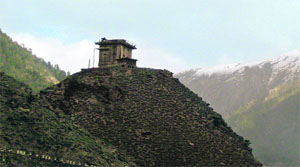
The Pandava Fort at Moorang
|
Time stops here
Not much has changed for
21st-century Kinnaur. Tucked away in the northeastern edge of Himachal
Pradesh, rubbing shoulders with Tibet, this high-altitude Himalayan
district faces splendid isolation in the heartless winter. Despite the
erosion of geographical seclusion (as a direct consequence of the
historic Great Road, today, motorable and known to us as the National
Highway 22), Kinnaur still presents an idyllic picture of life above
12,000 feet. Shattered every now and then by the man-induced wrath of
nature. Crisscrossed by the formidable, albeit magnificent, Zanskar,
Dhauladhar and Greater Himalaya ranges, Kinnaur is bestowed with
innumerable peaks, valleys, glaciers and deep gorges carved out by the
Sutlej and its tributaries. The capricious Sutlej announces its
thunderous presence in India a short distance from Shipki, the last
village on the Tibetan side, before lashing through to the plains of
Punjab.
Snaking along, above,
and across this redoubtable river are the many treacherous footpaths
trod by traders, surveyors and travellers of yore; ferrying goats,
wool, borax, spices, opium and espionage between Rampur on the left
bank of the Sutlej, and the tent-city of Garu in China. Accessed
through the Shipki Pass at 16,000 feet, ancient traders thought
nothing of marching for over a month to participate in Rampur's annual
Lavi trade fair; a vibrant tradition that continues, centuries later,
come November.
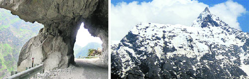
Jorkanden Peak (foreground) with the
Shivling-shaped rock formation atop Kinner Kailash (extreme right)
Stone archway on the Hindustan Tibet Road |
Commercial route
It was Lord Dalhousie's
visits to Bushahr that led to the re-examining of possible commercial
routes as envisaged during the Gurkha wars. Through the treaty of
1815, the hill states had bound themselves to constructing roads
within their territories when called upon by the colonial government.
Following the ceding of free land by the states of Patiala, Baghat and
Keonthal, the first lap of the Hindustan-Tibet Road from Kalka to
Shimla commenced in the year 1849. Soon after, hunting and sightseeing
trips along this road became the main attractions of the Shimla
season, but the Governor General found the hill station over-rated.
Terming it 'merely a suitable eyrie from which to watch the newly
annexed plains that stretch below', he preferred instead to conduct
his official duties out of Chini. The dry weather, and possibly, the
unmatched view of the Kinner Kailash bathed in moonlight, placed him a
mere forty-six mail hours, or four marching days away from the Summer
Capital. In a private communication to a friend, Lord Dalhousie
dreamily shared, "I returned to Simla by the new road, which I
commenced one year ago, and which when it shall be finished will not
be surpassed, I flatter myself, by any mountain road in the
world". In practice, regrettably, he could not convince the Board
of Control in London, already reeling from the Punjab conquest, about
the low cost of construction, despite pressing forced labour into use.
Consequently, while the Cart Road between Kalka and Shimla would
proudly ferry wheeled traffic by the 1860s, the road beyond Shimla
would remain a small cut bridle path, never more that 7 to 8 feet in
width. It would zigzag through Theog, Narkanda and Kotgarh to Rampur,
across the Wangtu Bridge to culminate at Chini.
Broader NH 22
 Today, a newer, broader
NH22 has replaced the bridle path; essentially following the same
route till Wangtu. Hereon the highway meanders along the left bank of
the Sutlej towards neighbouring Spiti. At Khab (confluence of the
Sutlej and Spiti rivers), an off-shoot ascends to Namgea, a couple of
hours run from Shipki Pass and the India-Tibet border beyond. This new
alignment of the highway has placed Chini on an ancillary road through
Rekong Peo, Kinnaur's modern-day capital; an ugly, congested township
with marvellous views of Jorkanden, the highest peak of the Kinner
Kailash massif. Hydro-electric power projects straddling the Sutlej,
Nathpa Jhakri and Karcham- Wangtu, have changed the character of this
once-serene landscape. Construction and plying of heavy trucks over
the years has resulted in deplorable road conditions. Not too long
ago, a section of the NH22 was featured in the History Channel's Deadliest
Roads series for its hazardous driving conditions. Proving
emphatically, that the more things change, the more they stay the
same. Even a 150 years apart. Today, a newer, broader
NH22 has replaced the bridle path; essentially following the same
route till Wangtu. Hereon the highway meanders along the left bank of
the Sutlej towards neighbouring Spiti. At Khab (confluence of the
Sutlej and Spiti rivers), an off-shoot ascends to Namgea, a couple of
hours run from Shipki Pass and the India-Tibet border beyond. This new
alignment of the highway has placed Chini on an ancillary road through
Rekong Peo, Kinnaur's modern-day capital; an ugly, congested township
with marvellous views of Jorkanden, the highest peak of the Kinner
Kailash massif. Hydro-electric power projects straddling the Sutlej,
Nathpa Jhakri and Karcham- Wangtu, have changed the character of this
once-serene landscape. Construction and plying of heavy trucks over
the years has resulted in deplorable road conditions. Not too long
ago, a section of the NH22 was featured in the History Channel's Deadliest
Roads series for its hazardous driving conditions. Proving
emphatically, that the more things change, the more they stay the
same. Even a 150 years apart.
|
Mythology
rules
|
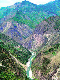
The Sutlej viewed from an older ridge road above the NH22 Photos by the writer
|
Kinnaur is a
land seeped in mythology, nurtured and contained, no doubt, due
to the inaccessibility of the region. Ancient Indian texts
considered the mystical Kinners (people of Kinnaur) as
supernatural beings, halfway between humans and gods. The Kinner
Kailash range is purportedly the mythical winter abode of Lord
Shiva. The Pandavas, too, chose Kinnaur to spend their last year
of exile in. Visible from across Jangi, on the old
Hindustan-Tibet Road, is a hamlet called Moorang, the name
indicating a place where three water channels meet. Remarkable
for the strikingly beautiful mountains surrounding the village,
as much for a distinct mud structure crowning a rocky hilltop in
the foreground. Silhouetted against the sky and the snowy peaks,
it is an antediluvian structure of indeterminate architectural
style and age. The Pandava Fort is supposed to have been built
by them during their stay here; it presently houses Ormig Devta,
the reigning deity of the village.
Hungary to
Kinnaur
Philologist and Orientalist,
Csoma de Koros is widely acknowledged as the founder of
Tibetology. An interest he stumbled upon while trying to trace
the origin of, and establish a connection between, the Magyars
and the Uyghurs of Central Asia; believing they shared a nomadic
ancestry. In 1820, he sailed for Turkey, Cyprus, and Egypt
before joining, at Beirut, a caravan for Baghdad. The Central
Asian war forced him to move south towards Peshawar, from where
he accompanied French officers Jean-Francois Allard and Jean-Baptiste
Ventura to Lahore. He planned to visit Yarkand, using the
commercial routes over the Karakoram via Leh, but had to abort
plans due to the dangers involved. It was during this period
that he met William Moorcroft, a British officer, who presented
him a copy of Alphabetum Tibetanum, supposedly the first book on
Tibet, an absolute terra incognito, thus far. Hoping, clearly,
to discover new sources about the history of ancient Hungarians
in there, he decided to learn Tibetan, using Persian as an
intermediate language. Csoma would spend the rest of his life
involved in one way or the other in Tibetan studies. In 1825 the
government of India granted him a modest monthly stipend of
fifty rupees, and in return he promised to produce a dictionary,
grammar, and short accounts of Tibetan literature and history.
While in Zanskar, he amassed a huge collection of Tibetan
manuscripts, retiring with them to a cottage in the village of
Kanum on the Sutlej River in Upper Bashahr from 1827 to 1830. He
spent those years under extreme privation while immersed in the
study of the Tibetan language under the tutelage of Lama Sans-rgyas-phun-tshogs.
It was here, in an almost-forgotten hamlet in Kinnaur, that the
first ever Tibetan-English dictionary, comprising over 30,000
words, was compiled by Alexander Csoma de Koros, an accidental
student of the subject. |
|
