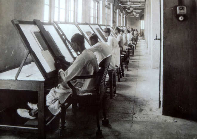
Duffing’ section staff at work in the Survey of India office, Calcutta. Photograph, ca. 1890s. The British Library, London
B.N. Goswamy
“On examining scores of maps of India, spread over five centuries, it is my view that war and commerce were the main drivers of map-making in our country. If that were not the case, would we not have seen a significant number of maps expressing alternative images of the country? …There was little interest of the map-makers of the Company and the Raj in documenting subjects beyond strategic military requirement and their direct interest in administration and exploitation of their territories.”
“The Company’s need for reliable strategic information to plan campaigns, record territorial gains, identify sources of commercial products, estimate revenue collections and, sometimes, a passionate thirst for knowledge, led to an immense volume of maps being produced …”
— Manosi Lahiri, Mapping India
“The almost impassable barriers of the greatest mountain range in the world have been unable to arrest the progress of (our) work, for the mighty Himalaya has been crossed and re-crossed, and out stations planted on peaks never before trodden by the foot of men ….
The swampy morasses and deadly forests in several parts of India have been traversed and mapped, while many tracts of hilly country covered by primeval forests have been covered by our stations and successfully surveyed.
The desert has been crossed by our triangulation, and several series of great length carried across the Runn (of Kutch)…”
— Andrew Waugh, in his farewell order, March 1861
Seemingly, there is a contradiction between the two lengthy statements I have cited above: the almost accusatory air of the first appears to be countered by the nearly boastful, at least self-assured, vein that runs through the second. But, truly speaking, these pronouncements are not at odds with each other at all, for Manosi Lahiri (from whose work I cite so much) was talking about the very early days of ‘scientific’ map-making in India, while Andrew Waugh, who headed the Survey of India, was speaking at a time nearly a hundred years removed from those early days. The times had changed; and so had their tenor. One realises that there is truth in both statements.
As nearly everyone knows, there is unending fascination in the subject of map-making but also, somewhere, a challenge. For the range to be explored is vast, and the materials widely, despairingly, scattered. Take the case of India alone. If one imagines that here it all started with and by the British, one would of course be wrong. For how can one be unaware of the Mughals’ absorbing interest in maps, judging from the manner in which a court painter must have been asked to bring in a version of Linschoten’s 1596 map of the Lands of the East in that celebrated painting in which the emperor Jahangir embraces Shah Abbas of Persia: the two potentates standing firmly on the globe? Or forget those long painted scrolls in which the painter/map-maker ‘recorded’ the Dogra General Zorawar Singh’s daring campaign to conquer Ladakh and beyond, moving through some of the most treacherous terrain in the world? Or, yet again, the maps in which Kutchi sailor/navigators — mallams, in local terms — used to chart their course across the waters on the way to the eastern coast of Africa? Clearly, there was a tradition here, and meaningful interest.
However, things changed, as they were bound to change, when the British began to establish a firm foothold in India. In some ways, the landmark Battle of Plassey, which Robert Clive won, wresting vast tracts of land from the Nawabs of Bengal, marked a turning point. ‘They now needed to know more about the land to assess the potential for revenue’, as Manosi says, ‘and to mobilise an army to defend it’. This led to the first surveys of Bengal, setting into motion the process of making ‘modern’ maps of India. In 1764, James Rennel was appointed Surveyor General to the ‘Hon’ble United Company of Merchants of England trading to the East Indies’: the East India Company in short. His first activities took the form of a survey of the Bengal Delta and its rivers. The channels of the tributaries of the Ganges-Brahmaputra river systems were recorded; the navigable channels connecting ‘the salt works’ were drawn; settlements along the river were mapped. Everything was taken into account: “the bends in the river, the islands and sand banks, the gentle slip-off slope, the steep cliffs along the concave bend …” The maps thus surveyed were published in England in 1776 by the publisher Andrew Dury, who presented them to the Directors of the Company with these words inscribed at the top right of the printed sheets: “Gentlemen: As the General Good of the Honourable Company whose affairs You have so Successfully directed, was the Motive that prevailed upon You to allow the Valuable MAP of those rich and extensive Provinces of Bengal, Bahar &c. to be published to the World, I am happy in this Opportunity of testifying to the Public, to whom they owe this great addition of Geographical knowledge, and at the same time of Subscribing myself.” He signed off with the words: “Your most Obedient, And much Obliged, Humble Servant, Andrew Dury. 1776”.
A benchmark had been established. And upon his return to England, in 1779 James Rennel published, on the basis of his work in India, a Bengal Atlas, ‘containing Maps of the Theatre of War and Commerce on that Side of Hindoostan’. That ‘Bengal and Bahar’ comprised ‘a Tract more extensive and populous than the British Islands’ was emphasised when Rennel dedicated the Map to Warren Hastings who had by then been appointed ‘Governor General of the British Possessions in Asia’. Those were the beginnings, and so much more was to follow in the 19th century. The Great Trigonometrical Survey was taken up as a project which aimed at measuring the entire Indian subcontinent ‘with scientific precision’. It was begun in 1802 by William Lambton, who was succeeded by George Everest, after whom Mount Everest is named. The completion came in 1871.
It was all a part of the great Survey of India which now speaks of itself as being ‘the oldest scientific department of the Government of India’. Clearly, things have come a long, long way since the 60’s of the 18th century. In the offices of the Survey of India today, everywhere you read the proud words:
"We know every inch of the nation, because we map every inch of it.”


