Tribune file photo
Tribune News Service
New Delhi, October 5
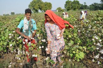
The Central Government launched its flagship Kisan—C(K)rop Insurance using Space technology And geoiNformatics — project on Monday to speed up payment of crop insurance claims to farmers and provide accurate assessment of crop damage.
The government has begun a pilot study under the scheme in rice and cotton fields of the ongoing kharif season in four districts—Kurukshetra (Haryana), Shimoga (Karnataka), Yavatmal (Maharastra) and Seoni (Madhya Pradesh). The survey will be carried out into the 2015-16 rabi season in eight districts in same states to assess the yields of rice, wheat and shorghum, said Minister of State for Agriculture Sanjeev Kumar Balyan.
The project uses satellite and drone-based imaging and other geospatial technology to get accurate data on crop yields.
“It will eventually cover the entire country once we assess results,” Balyan said. “Crop Insurance are usually calculated on the basis of crop cutting experiments, often leading to delays in settlements. The project will address these concerns.”
The government also launched an Android-based app for collection of data of hailstorm with assistance from Indian Space Research Organisation (ISRO) to assess large-scale damage to standing crops. State agriculture officials will use the facility to help the Central Government make quick assessment of damage to crops.
Hailstorms cause large-scale destruction to standing crops. Currently, there is no comprehensive approach to collect data on their occurrences.
The application will collect data about hailstorms in real time along with photographs and geographical coordinates. This will help survey crop loss quickly and more objectively.
The data collected could then be uploaded on ISRO's Bhuvan server. The programme envisages use of high-resolution remote sensing data — both from satellite and drone-based imaging — sophisticated modelling activity and other geospatial technology for accurate estimation through efficient crop-cutting experiments.
Block-level yield estimation and development of a new index- based insurance approach using remote sensing data are also planned under the project.
Mahalanobis National Crop Forecast Centre, ISRO, India Meteorological Department, State Agriculture Departments and Remote Sensing Centres, Climate Change, Agriculture and Food Security (CCAFS) will jointly conduct the programme.
Most Read In 24 Hours
Don't Miss
View All


Top News

9 burnt to death as bus carrying devotees from Punjab catches fire near Tauru in Haryana
Devotees were returning from pilgrimage to Mathura and Vrind...

Swati Maliwal FIR alleges brutal assault, AAP calls it BJP ploy to frame Arvind Kejriwal
CM’s aide files counter-complaint | Says was abused by MP | ...

Navjot Sidhu on star campaigner list, but missing from poll scene
Party insiders reveal that his political relevance cannot be...

Girl among 4 law students killed as their speeding SUV crashes near university in Punjab's Patiala
The impact of the collision was so intense that police had t...

Missing Taarak Mehta Ka Ooltah Chashmah actor Gurucharan Singh returns home after 25 days, ‘had embarked on a spiritual quest’
Singh says he spent time in several gurdwaras of Punjab