THE U.N. Development Programme’s study team has not taken long in approving India’s tentative plan for a national water grid, including the Ganga-Cauvery link. Far from dismissing the idea as too chimerical, the mission has urged that it is going to be a necessity for meeting the country’s water requirements by the end of the century, and hence it is none too early to start the preliminary work, which itself will take a massive effort. A hard-pressed generation will have to strain itself in finding the resources for a series of giant projects which, according to rough estimates, will mean in all a figure of Rs 2,875 crores. If navigation facilities are excluded, the costs will be only Rs 2,200 crores. But the U.N.D.P. has emphasised the importance of facilitating inland navigation in the coal belt which falls within the region of the water grid, especially because there is no other natural north-south waterway which can serve the purpose. For a country of this size and population, it would be ideal to develop inland navigation as a cheaper alternative to rail and road transport. The cost is forbidding, no doubt, but when planning is done over such a long time-span the infrastructure for meeting future needs has to be provided. Dr. K.L. Rao, Union Minister for Irrigation and Power, said at a press conference last week that the water grid programme had been referred to the U.N. experts mainly to have a study in comparison with similar schemes elsewhere. In the U.S. and the U.S.S.R., inter-basin transfer of waters is being done on a far bigger scale than is envisaged in our plans. For the proposed Ganga project, 2 million acre feet of water have to be pumped up, and that too up to a height of 1,300 feet. The Soviet scheme of making north-flowing rivers run south is perhaps the most daring in this field.
Join Whatsapp Channel of The Tribune for latest updates.
Most Read In 24 Hours
Don't Miss
View All


Top News


Deeply biased: MEA on US report citing human rights violations in India
The annual report of the State Department highlights instanc...

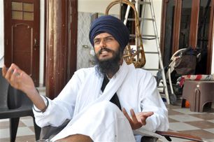
Couldn't talk due to strictness of jail authorities: Amritpal's family after meeting him in jail
Their visit comes a day after Singh's legal counsel Rajdev S...

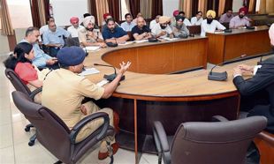
Centre grants 'Y' category security to Phillaur MLA Vikramjit Chaudhary and 2 other Punjab Congress rebels
The Central Reserve Police Force has been directed by the Mi...

First Sikh court opens in UK to deal with family disputes
According to ‘The Times’, the Sikh court was launched last w...