
![]()

Saturday, May 29,
1999
|
|
     
|
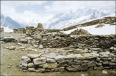
Haphazard development has accentuated the vulnerability of the Himalayan region to earthquakes, says Radhakrishna Rao. THE devastating earthquake that ripped through the hilly region of Uttar Pradesh killing about 100 people and causing widespread destruction in March this year has once again brought into sharp focus the vulnerability of the Himalayas to seismic activity. The killer quake, measuring between 2 and 4.9 on the Richter scale, was not wholly unexpected, with researchers and seismologists repeatedly drawing attention to the fact that the Himalayas are prone to seismic convulsions. Even as scientists are struggling to figure out the cause of the recent Chamoli Rudraprayag earthquake, environmentalists blame it on indiscriminate deforestation and the flattening of mountains to build roads and dams.
Prof K.S. Vaidya, a well-known expert on Himalayan geology, remarks, "The Himalayas are rising continuously. Movements are occurring along faults because peninsular India is pushing the mountain range at a speed of 5.5 cm per year. This is expected to continue forever and so the Himalayas will remain dynamic." Dr V.P. Thakur, Director of the Dehra Dun-based Wadis Institute of Himalayan Geology, points out that the epicentre of the recent quake was estimated to be 30-35 km deep compared to the 1991 Uttarkashi quake, the epicentre of which was located 15 km deep. Himalayan Uttar Pradesh has had a long and chequered history of landslips, landslides and earthquakes. Much before the Uttarkashi killer quake of 1991, Professor Jayanto Bandopadhyaya of the International Centre for Integrated Mountain Development at Kathamandu had pointed out that in 1802 a major quake had hit the western Kumaon region. According to Professor Bandopadhyaya, indiscriminate deforestation in the Himalayan foothills, coupled with the loosening of the soil structure in the entire hill region, has been responsible for floods and landslides at a recurring frequency. Geologists are never tired of saying that compared to the other mountain ranges in the world, the Himalayas are very young from the geological point of view and hence very unstable. Being in a perpetual state of growth, the region is prone to intense seismic activity. The seismically active Himalayas, experts say, could be disastrous to the Tehri dam. The site of the Rs 3000-crore Tehri dam, designed to impound the waters of the Bhagirathi river, is located very close to Uttarkashi, a seismically active region. Against such a backdrop, Dr James N. Brune of Nevada University had warned that in terms of the hazard rating of the International Commission of Large Dams, the Tehri dam location is in an extremely hazardous zone. According to another well-known seismologist, Harish Gupta, "It is important to have a fault zone well monitored because the earth sometimes speaks in whispers." To cut a long story
short, the young and dynamic Himalayas can easily buckle
under the stress exerted by human activities. As it is,
most parts of the Himalays are poorly cemented
conglomerates of sandstone and happen to be of relatively
recent origin. Against this backdrop, cutting down the
trees which bind the soil together and dynamiting the
geological base of the mountains for building roads, have
accentuated the process of soil erosion, landslides and
earthquakes. — ANF |
|||||
| Good Motoring and You | Dream Analysis | Regional Vignettes | | Fact File | Roots | Crossword | Stamp Quiz | Stamped Impressions | Mail box | |

 Some researchers are of the view that the
Himalayan region is prone to quakes because of the north
and northwesterly movement of the Indian plate at the
rate of about 5 cm per year, and its collision with the
Eurasian plate, which is relatively stationary. It is
speculated that these movements give rise to an
accumulation of stress, and as it exceeds the bearing
capability of the rocks, quakes occur due to rock
slippages. But Dr H.N. Srivastava, Emeritus Scientist at
the Council for Scientific and Industrial Research (CSIR)
in New Delhi, argues that the occurrence of quakes in the
Himalayan region is "very chaotic" and cannot
be predicted on a long-term basis. Dr Srivastava says,
"In a terrain like the Himalayan region, the
intensity decreases at a much faster rate with distance
than in the plains. The rapid attenuation in low
frequency implies that only high rockfill dams should be
constructed in these areas."
Some researchers are of the view that the
Himalayan region is prone to quakes because of the north
and northwesterly movement of the Indian plate at the
rate of about 5 cm per year, and its collision with the
Eurasian plate, which is relatively stationary. It is
speculated that these movements give rise to an
accumulation of stress, and as it exceeds the bearing
capability of the rocks, quakes occur due to rock
slippages. But Dr H.N. Srivastava, Emeritus Scientist at
the Council for Scientific and Industrial Research (CSIR)
in New Delhi, argues that the occurrence of quakes in the
Himalayan region is "very chaotic" and cannot
be predicted on a long-term basis. Dr Srivastava says,
"In a terrain like the Himalayan region, the
intensity decreases at a much faster rate with distance
than in the plains. The rapid attenuation in low
frequency implies that only high rockfill dams should be
constructed in these areas."