
Sunday, May 2, 1999
|
Sunday, May 2, 1999 |
  |
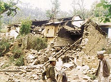
THE devastating earthquake which struck the Garhwal Himalayas on the night of March 28, 1999, killing 100 persons, injuring 324 and rendering thousands homeless, has again pointed towards the fragility of the Himalayas and the need to re-focus the development strategies in the entire Himalayan belt stretching from Jammu and Kashmir to the North-East. Large-scale death and destruction caused by the seismic activity on that fateful night has left lakhs of people homeless in Chamoli, Rudraprayag, Tehri and Pauri districts of Garhwal division and Bageshwar district of Kumaon division.
But the most unfortunate were the residents of the newly created Rudraprayag district. In August last year, the district, particularly the Ukkimath area, bore the brunt of massive landslides which killed more than 60 persons and destroyed many villages. Now the earthquake has further added to the woes of the poor residents. "The Garhwal region has gone further backwards by two generations after this tragedy, as it takes decades for the poor hill people to build pucca houses," lamented Anil Joshi of Himalayan Environmental Studies and Conservation Organisation (HESCO), a non-government body engaged in the relief operations. B.M. Vohra, Divisional Commissioner, Garhwal said that according to a preliminary survey, 7500 houses were damaged or destroyed in Chamoli district. In Tehri district 616 houses were totally damaged and 2000 houses were partially damaged, in Rudraprayag district 750 houses were completely razed to the ground, while 3160 houses were partially damaged. A survey has been going on to assess the damage to public property. Many roads which were blocked or damaged by the earthquake need repairs. The people are afraid to sleep inside their damaged homes as tremors are continuing since March 28 in the region. They are forced to spend their nights in the open. It is not only the tremors which the villagers dread but the danger of wild animals, particularly the maneater panthers and leopards on the prowl, which has made their lives miserable. More than the rations people require tents and tarpaulins to save themselves from the vagaries of weather and the wild animals. Vohra said that a total of 3200 tents and 20,000 tarpaulins have been distributed in the quake affected region. But demands for more tents have been pouring in from all the effected districts. Many social and voluntary organisations, besides the Army and the Indo-Tibetan Border Police (ITBP), have also pitched in to provide relief to the affected population. But the rugged and mountainous terrain of the area has proved to be a big hindrance in providing succour to the people living in the far-flung and remote villages. Helicopters are being used to drop relief material to the needy in those areas which are inaccessible or are cutoff due to damaged roads. There are also allegations that while the sufferers in the far-flung areas are feeling ignored as far as relief supplies are concerned, those living close to the roads are getting much more than what was needed. Col V.K. Chand, Commanding Officer of the 9th Rajputana Rifles, who went to Chamoli district voluntarily to extend help to the suffering masses said that his team had to trek for 15 long hours to reach Dumka village across the Alaknanda. Chamoli district is spread over an area of 19,000 sq. km, making the task of relief agencies much more difficult. What causes frequent earthquakes in the region? Scientists of the Wadia Institute of Himalayan Geology and the Roorkee University maintain that due to persistent northward drive of the Indian plate against the hardened Tibetan plateau, the whole of north India remains under stress. Himalayas, being one of the youngest mountains of the world, are very fragile. Moreover, the Garhwal and Kumaon regions which had witnessed eight major earthquakes in the century sit on the main central thrust, one of the two fault lines across the entire Himalayan stretch, making it quake-prone. Ironically, with people forgetting their ancient wisdom in making traditional houses and aping the western concept of houses, none of the houses in the area are quake resistant.R.N. Dubey, earthquake engineer from Roorkee University, who along with his colleagues visited the affected areas, said that the university had recommended construction of houses after the Uttarkashi earthquake in 1991. However, the recommendations remain on paper.
The scientists strongly feel that it should be made mandatory through legislation to built quake-resistant houses. P.S. Saklani, Vice-Chancellor of Garhwal University, who himself is a geologist, was of the opinion that a cell should be formed to monitor that houses are constructed according to the specifications given for quake-prone areas. Commenting on the recurrent natural disasters and inadequacy of the rescue and relief operations in the mountains, Anil Joshi said that a disaster management cell should be set up at each district of every mountain state and similar cells should be formed right up to the village level. He argued that villagers should be made aware of the dangers of quakes, landslides, cloudbursts and floods, which frequently hit the people living in the mountain regions so that they should be prepared for any natural disaster, and the damage could be minimised. Scientists and
environmentalists are unanimous in their view that the
development strategies for the entire Himalayan region
need a basic change keeping in view the fragility of the
region and the increased seismic activity. |
| Interview | Bollywood Bhelpuri | Sugar 'n' Spice | Nature | Garden Life | Fitness | | Travel | Your Option | Time off | A Soldier's Diary | Fauji Beat | | Feedback | Laugh lines | Wide Angle | Caption Contest | |
 Chamoli district, which was the epicentre
of the earthquake, witnessed 60 deaths, followed by 34
deaths in Rudraprayag district. In Chamoli district alone
1256 villages were affected, having a population of
nearly 3 lakh.
Chamoli district, which was the epicentre
of the earthquake, witnessed 60 deaths, followed by 34
deaths in Rudraprayag district. In Chamoli district alone
1256 villages were affected, having a population of
nearly 3 lakh.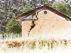 The
Centre has also set up a task force to survey the damage
and recommend quake-resistant house designs. The Roorkee
University team insisted that the guidelines of the
Indian Society for Earthquake Technology and Bureau of
Indian Standards should be followed in making houses on
the lines of those made in Latur in Maharashtra in 1993.
The
Centre has also set up a task force to survey the damage
and recommend quake-resistant house designs. The Roorkee
University team insisted that the guidelines of the
Indian Society for Earthquake Technology and Bureau of
Indian Standards should be followed in making houses on
the lines of those made in Latur in Maharashtra in 1993.