


In a first, drones used for aerial seeding in Shiwalik area

Tribune News Service
Panchkula, September 12
In a first-of-its-kind move, the Haryana Forest Department has taken up an initiative of greening of the Shiwalik area in Panchkula district by airborne dispersal of seed pellets of neem, jamun, amla and ficus species of bargad, papal, pilkhan, khair, etc.
The aerial seeding through drones that started today will continue till September 18. It is being said to be conducted on a pilot basis.
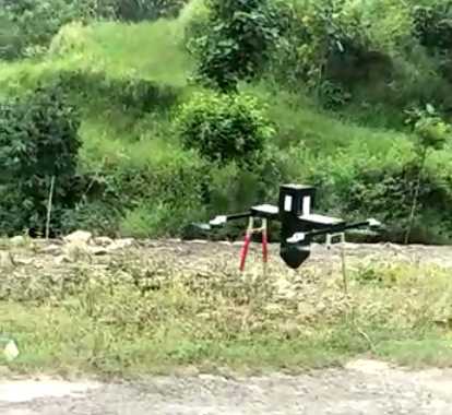
The seeding drone is developed by an IIT Kanpur start-up which is capable of taking a payload of 2kg and is equipped with precise delivery mechanism for seeds of different sizes to drop them at predetermined intervals from a low height of 10-15 metre.
Pawan Sharma, District Forest Officer, Morni, said this technology is cost effective and a single drone is capable of planting 20,000-30,000 seeds a day.
Haryana Chief Sectretary Keshni Anand Arora is taking personal interest in this technology and she was the one who guided the department to carry out aerial tree seeding operation in Shiwalik Area, he told The Tribune over phone.
Speaking on the occasion of pilot run of air seeding operation today at Mandhna, Anil Hooda, Principal Chief Conservator of Forests, said, “Drone based seeding will boost vegetation enrichment in denuded and in low density areas. It will also help plantation in inaccessible and tough terrains which are otherwise difficult for manual plantations.
He further said, “Drone based tree planting technology is very promising and holds immense potential for the future. However, this technology requires proven artificial intelligence based system to assess the area for plantation sites and selection of site specific local species. Soil moisture, choice of species, seed palleting and mechanism of drone seed planting are main deciding factors for a successful aerial tree planting.”
Vinod Kumar, Additional Principal Chief Conservator of Forests, said, “We are constantly using geospatial technology to precisely map forest boundaries, evaluating forest cover and monitoring forestry resources and assets. Geolocation of blank patches and low density areas can be mapped using latest satellite imageries and data so generated can be directly fed into drone software for auto plantation.
The forest department is currently working on the development of mobile-based app to collect forestry intervention and monitoring data from the field for better management of forest areas.”
Unlock Exclusive Insights with The Tribune Premium
Take your experience further with Premium access.
Thought-provoking Opinions, Expert Analysis, In-depth Insights and other Member Only Benefits
Already a Member? Sign In Now


