


Leaving behind deities of nature after strenuous trek

Avay Shukla
The Kinner Kailash range in the north-east of Kinnaur is considered by devout Hindus to be the abode of Shiva and doing its ‘parikrama’ or circuit is a pilgrimage as holy as visiting Mansarovar. Before expansion of the road network one had to walk from Karcham to Powari, Akpa Thangi, Lambar, Charang, Nalanti, cross the high Charang Ghati pass, descend to Chitkul in the Sangla valley and back to Karcham, always keeping the mountain on one’s right (see map). This involved a distance of about 220 km and took eight days. Now, however, the trek begins at Thangi or Lambar, covers just 100 km and can be accomplished in four days. It is nonetheless a strenuous trek and Charan Ghati itself is a monster at 18,000 feet.
The route from Thangi follows the Charangkhad; there is now a crude road to Lambar but our group trekked from Thangi itself. The first camp is at Lambar, a small hamlet of a dozen houses, surrounded by groves of apricot trees, which the locals harvest to make the famous “chulli” oil, which is used for cooking as well as for massages. The second day takes one to Charang (11,500 feet), all along the narrow gorge of the stream, the apricot and deodar gradually giving way to spruce, fir and oak as one ascends. After about 15 km, the valley ahead splits into two: on the left is the village of Kunnu and on the right is Charang, the second night halt. These are the last villages in the valley; beyond them is Tibet, two days’ walk away. Charang has an ancient ‘gompa’ or monastery, which contains historical weapons of war which, according to legend, were seized by local villagers from an invading Tibetan force many centuries ago. The ‘gompa’ is believed by some scholars to date to the 11th century, which, if proven, could make it as ancient as the more famous Tabo monastery in Spiti.
The really strenuous part begins the next day. It starts well, as one climbs out of the valley, a thousand-foot ascent over lush pastures still wet from the dew. But then the picnic is over: the track descends into the deep valley of a tributary of the Charang stream, and then follows it up over rocks and boulders for 18 km till we cross the stream at a place called Lalanti (14,000 feet). This is the last camping site before the pass, a camping ground for shepherds. They were there with their flocks on their way down, as it was now late August and beginning to get really cold. We were told that a snow leopard had killed four sheep there the previous night.
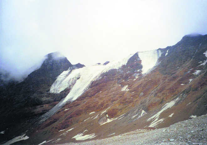
The fourth day involves 12 hours of determined trekking, through an unending expanse of boulders and rocks and the only vegetation is huge clumps of moss and lichen, and medicinal shrubs flowering in profusion. This is the domain of the Chitkuldevi who has decreed that no flowers or plants should be plucked on both sides of the pass. After five hours, one reaches the base of the pass (16,000 feet) and the snout of a glacier, the source of the stream we had been following these past two days. It is rugged terrain but imbued with the savage and intimidating beauty of nature. One’s heart sinks when one looks up at the Charang Ghati, a towering mass of scree and rocks 500 meters high draped in ice and snow on its crest, daring the climber to ascend its 90 degree slope.
It takes two hours to do so, for there is no track on the shifting, sliding surface of this weather-beaten feature. It is hard work, and dangerous, for falling boulders and loss of balance on the precarious footholds is a constant reality. Finally the saddle is attained, adorned with dozens of fluttering white flags. The view from the top is breath-taking: row upon row of peaks on the northern aspect, hyphenated by shimmering ribbons of glaciers and streams. The southern aspect is totally different, looking down into the verdant and beautiful Sangla valley, across which are the bewitching “kandas” or pastures of Sangla, topped by the peaks, which separate it from the remote Dodra Kwar valley, via the Rupen pass. It takes another two hours to negotiate the 6,000-foot descent to Chitkul, the last village and road-head in Sangla valley, beyond which lies the prohibited territory known as Rani Kanda, over which the ITBP maintains constant vigil. It is customary to pay one’s respects and offer thanks for a safe journey at the temple of the Chitkuldevi. We did so, and deposited our aching bones in an SUV and motored down to Karcham, leaving behind the deities of nature for our own urban gods.
Unlock Exclusive Insights with The Tribune Premium
Take your experience further with Premium access.
Thought-provoking Opinions, Expert Analysis, In-depth Insights and other Member Only Benefits
Already a Member? Sign In Now


