


Tracking Fani: 13,500 km in nine days

Vibha Sharma in New Delhi
Cyclone Fani, or Foni as it is pronounced, was unique in many ways. The longest lasting cyclone in the Bay of Bengal, Fani travelled 13, 500 km in nine days to reach its destination on the Odisha coast.
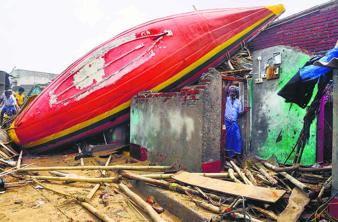
The second strongest cyclone to affect the state since Phailin in 2013, the cyclone caused widespread displacement of people and damage to property and infrastructure but accurate and timely prediction of its course and characteristics by the IMD, besides subsequent action by the administration, helped save tens of thousands of lives on the densely populated coast of east India.
Retracing Fani, Dr M Mohapatra, head of the cyclone warning division of the IMD, the Regional Specialised Meteorological Centre for Tropical Cyclones over North Indian Ocean, says first signs of the cyclone were noticed on April 18. It was first seen live as a depression on April 26. And it ended as a low-pressure area on May 4. According to Mohapatra, who is also known as ‘the cyclone man of India’ for having predicted many events accurately, its detailed study will answer questions as to why Fani behaved the way it did because several of its features make it unique and interesting in more ways than one.
Good pre-disaster management
Fani was one of the biggest cyclones to hit the Indian coast in past two decades, the most devastating being the Odisha Super Cyclone of 1999 that killed over 10,000 persons, besides causing massive damage to infrastructure and property.
However, lessons from past experiences helped save thousands. One of the main reasons for the high casualties then was late warning and absence of structured disaster management mechanism in the coastal states, besides lack of preparedness among the stakeholders. So while credit must go to the IMD for giving ample time, an equal credit must also go to different stakeholders subsequently in taking action on a war footing.
According to Mohapatra, the IMD gave first indication about the system in its bi-weekly forecast issued on April 18. Subsequent forecast on April 25 predicted higher probability of cyclogenesis over east equatorial Indian Ocean and adjoining central parts of South Bay with a North Westward movement. On April 29, the IMD predicted that Fani would intensify into a very severe cyclonic storm over the next 24 hours, move North-Westard till May 1 and re-curve North-North-Eastward towards the Odisha coast.
In its April 30 forecast, the weather office warned of it intensifying further into an extremely severe cyclonic storm and the landfall — the Odisha coast between Gopalpur and Chandbali to the south of Puri on May 3 afternoon with maximum sustained wind of speed 175-185 kmph gusting to 205 kmph.
Taking on the challenges
The initial thrust of the cyclone was handled well by the administration but challenges remain in terms of relief and rehabilitation, provision of safe drinking water, medical assistance, epidemic control and restoration of power and communication.
That does not, however, take the credit away from the efforts of agencies concerned of the Central government (the IMD, NDMA, NDRF, Navy, Army and Airforce), state administration (Odisha State Disaster Management Authority and Odisha Disaster Rapid Action Force) and other government and non-government agencies in averting a major disaster.
Improved early warning dissemination systems, response capacity of local communities, access to emergency shelters, evacuation and protection against wind storms, flooding and storm surge in coastal areas — all contributed to that.
The incredibly low figure of casualties in some recent extremely severe cyclones needs to be seen in the backdrop of increase in population in coastal Odisha by almost 50 per cent in the past 20 odd years.
Improved technology has made it possible to predict at least five days in advance the area of occurrence, time and point of landfall, wind velocity and wave height of a cyclone, giving ample time to disaster management to get into action, says Mohapatra. The Ministry of Earth Sciences, National Centre for Medium Range Weather Forecasting, the Indian Institute of Tropical Meteorology, the Indian National Centre for Ocean Information Service, National Institute of Ocean Technology, the Indian Air Force, Navy, IIT (Bhubaneswar) and IIT(Delhi) all provided modelling and observation support to the IMD, adds Mohapatra.
When the Super Cyclone of 1999 struck, there was only 24-hour prediction warning available. Today state-of-the-art Indian satellites are keeping a constant watch on the Indian region providing weather pictures every few minutes.
How unique has Fani been
- Place of origin: It started close to the Equator at 2.7º North. Usually tropical cyclones in these parts originate around 5º N.
- Sea route: Fani travelled 13,500 km to 19.7ºN of the Equator. Such a long life cycle for a cyclone during this time of the year has not been observed since long.
- Re-curving track: Normally, cyclones in the Bay of Bengal travel North-Northwest but Fani changed path to North-Northeast, re-curving towards the Odisha coast.
- Rare landfall: After hitting the coastline at Puri, it travelled across the coastal Odisha to West Bengal to Bangladesh, ending as a low pressure system over central Assam. This is rare because normally after making the landfall, cyclones travel inland.
- Remained strong: Fani maintained its intensity for almost 24 hours after the landfall. Normally cyclones weaken in six to 12 hours of touching land.
Unlock Exclusive Insights with The Tribune Premium
Take your experience further with Premium access.
Thought-provoking Opinions, Expert Analysis, In-depth Insights and other Member Only Benefits
Already a Member? Sign In Now


