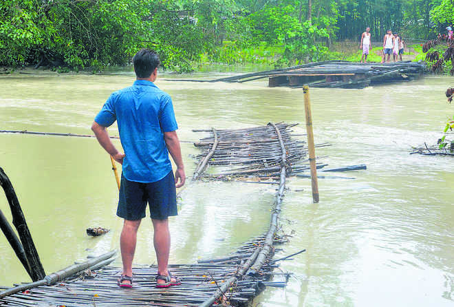
STRANDED: People look on at a bridge that was washed away in floods at a village in Nalbari district of Assam on Friday. PTI
Tribune News Service
NEW DELHI, JULY 26
India has activated a less-used mechanism of seeking international assistance for information about its severely flood-affected regions. India has so far received satellite data on the flood-affected North-East region and Bihar from eight countries, including the US, France, China and Russia, the External Affairs Ministry said here today.
“Under the charter, so far data has been received from eight countries, including USGS (United States Geological Survey), CNES (Centre National d’Etudes Spatiales), ESA (European Space Agency), Roscosmos (Russian space agency), CNSA (Chinese National Space Agency) and three others,” said Ministry of External Affairs spokesperson Raveesh Kumar.
The MEA’s disclosure about the charter having been activated by India nine days ago was in response to a query on sharing of satellite data for flood relief efforts. The MEA’s statement appeared after a social media posting by the new Chinese Ambassador Sun Weidong that “following ISRO’s (Indian Space Research Organisation) request for international disaster relief support, China has provided India with satellite data on its flood-hit regions to assist its flood relief efforts.”
India had activated a multilateral mechanism for sharing space-based data for countries affected by natural or man-made disaster. Recognising that a single operator or satellite cannot meet the demands of disaster management, “whenever there is a natural disaster, the National Remote Sensing Centre (NRSC) and member space agencies of 32 other countries which are a part of the International Charter Space and Major Disasters can activate the platform,” explained Kumar.
The charter then seeks the information pertaining to the disaster-hit area available with all 33-member space agencies. “This is the standard practice,” he said.
33 nations’ platform to share information
- MEA spokesman Raveesh Kumar said whenever there is a natural disaster, the National Remote Sensing Centre and member space agencies of 32 other countries seek information pertaining to the disaster-hit area available with all of them
- By combining earth observation assets from different space agencies, the platform allows resources and expertise to be coordinated for rapid response to disaster situations, he said


